
The tradition of a wet & blustery October has returned once again this year with a good few inches of rain being dumped over the next few days & into early next week. October is traditionally the wettest month on average so it is no surprise that true gloom & doom has arrived.
It is all to do with pesky low pressure & the jetstream being ‘meridional’ & diving south, introducing colder air & sending the track of low pressure directly overhead, compared to the usual route to the north of the UK.
Storm Alex
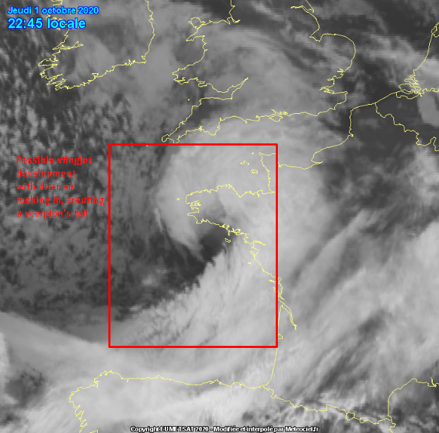
Storm Alex arrived late last night with satellite & observation indications of a sting jet forming on its western bank.
It underwent rapid cyclogenesis as it neared an amplified part of the jetstream, allowing the rapid deepening to happen & causing a nasty, powerful low-pressure system to arise.
The Met Office had identified it as a Stage II Shapiro-Keyser cyclone. Shapiro-Keyser cyclones are known to possibly create sting jets. A sting jet is a rapidly descending localised area of cold air inside a cyclone. Dry air rapidly rushes into the cyclone, otherwise known as a dry intrusion & as a strong flow of cold air forms inside the cyclone, the precipitation from the cold conveyor evaporates & cools. This all happens way up into the air around 3/4 km up & because the colder air is denser, it rapidly descends to the surface, causing a narrow space of accelerated air, forming a jet. These can cause wind gusts of well over 100 mph.
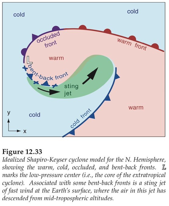
A visual diagram of the aforementioned sting jet.
It is dubbed a sting jet due to the scorpion tail look it takes on satellite imagery with a notable cloud head curling into the tail.
They are the main cause of the tremendous winds seen in the Great Storm of 1987, causing widespread damage across the south, which was completely unforecast & unexpected.
The same was seen last night with a notable cloud head curling into the scorpion’s tail & water vapour satellite imagery showed drier air rushing into it.

Ground observations from Belle-île-en-mer, an island off the coast of Brittany confirmed some suspicions of a sting jet with a gust of 115.6 mph just after 11 pm UK Time. This beat the previous record there from the Great Storm of 1987 which was 162 km/h (100.6 mph). Luckily, gusts of near that magnitude were only recorded in that one spot & elsewhere got nowhere near such speeds. It does go to show the magnitude of these storms when an amplified jetstream is involved!
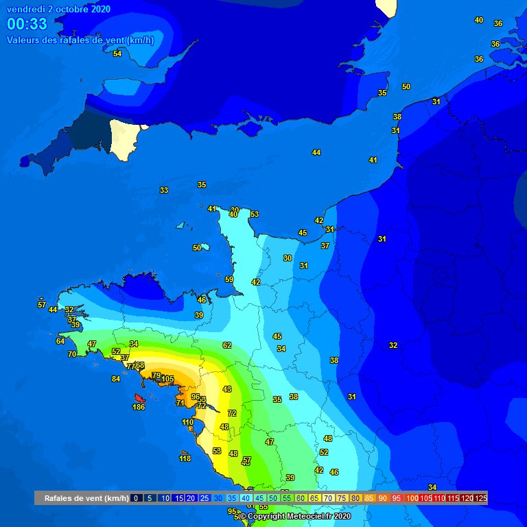
The aforementioned wind gust can be seen to the bottom left of the image.
Why am I telling you all this?
This storm is the reason we all are currently getting bathed in rainwater. The nature of the storm is that it has hung around in the Channel & is slowly backing down south into France currently.
This is the perfect combination for the rain to simply just keep on coming & coming with flooding already being seen in places such as Southampton, in which a primary school has been flooded from the amount of rain that has fallen.
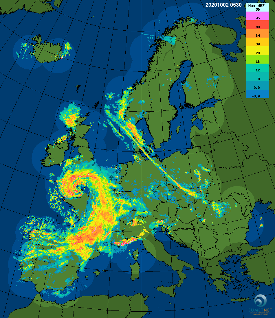
NW Europe Radar Still at 05:30 UTC, showing the outer rain bands of the low-pressure system heading towards the UK.
Rainfall radar estimates as of 17:00 show that many places, especially in Hampshire & Sussex have been hit the worst with an inch to two inches of rain falling within the last 24 hours. A yellow weather warning is out for the South East as well as an amber stretching from Dorset into Wales.
This is set to continue for the next days as a copy-cat system reappears from the depths of Storm Alex, bringing more rain to the UK & in turn more chances of flooding. More details are below!

Rainfall estimations using radar observations from 01/10/2020 16:00 UTC – 02/10/2020 16:00 UTC

Manual rain gauge showcasing the 25 mm of rain (an inch) that has fallen over the last 24 hours.
(01/10/2020 16:30 UTC – 02/10/2020 16:30 UTC)
What is this new low-pressure system?
It is a new system that spawns off the other one as its brother in crime & brings the weather fronts along with it. It brings rain tomorrow morning & that rain moves a little before eventually stalling in the afternoon.
The wind gusts in this low-pressure system aren’t anything to take of note; the rain is.
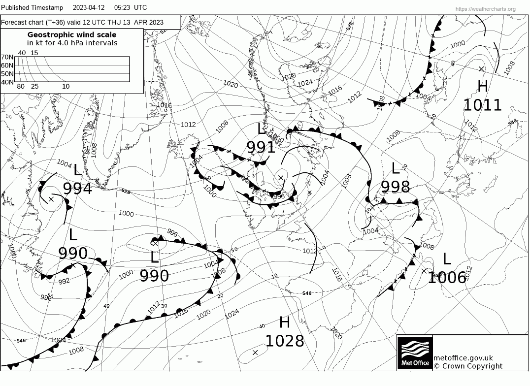
Met Office FAX showing the new low-pressure system & the stalling weather front forecast for tomorrow afternoon.
The stalling weather front as a result of a weather front from a new low-pressure system in France can be seen here.
The main thing is certain, however, Hampshire & Dorset into Somerset are the ones most at risk of being completely stuck under a deluge of rain. No-one knows the one spot that is going to get the most but a deluge is certainly coming.
It’s a mixed bag but it is certain that this weekend is a washout before better conditions start to arise mid-next week with the sun returning for a little bit!
Enjoy your weekend everyone & stay safe!
Jamie