It has been an incredibly wet start to October here in CS England with many places reaching well over 60 mm of rain within the first 2/3 days of the month. Many official stations are over 60% of their monthly average already this month with some such as Benson at 126% with a monthly total standing at 86 mm.
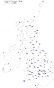
Roger Brugge’s automated rainfall average map for stations in the UK at 06:00 UTC on the 4th of October.
It is not often that you see Central Southern England at the forefront of most of the rain. with Reading recording the second wettest 48 hour period on record with 83.2 mm, stretching all the way back to 1908.
We await official confirmation, but unprecedented wet spell here in Reading and other places. pic.twitter.com/YcLIuUDWW2
— Daniel Harris (@DJHWeather) October 4, 2020
Here in Herne Bay, the first 4 days of October have been wetter than every month’s monthly rainfall total apart from February. This year truly has been filled with dry to wet flips. For instance, an incredibly dry Spring led to the very wet & thundery start to Summer. Some have attributed these dramatic flips to our ever-changing climate.
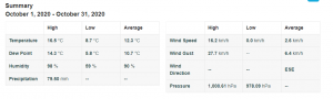
The monthly rainfall totals from my weather station this month so far at 16:00 UTC on 04/10/2020.
109.5% of the monthly average
I also recorded the wettest day for many years with 37.31 mm of rain falling within 24 hours on Friday the 2nd.

AWS rain readings from 00:00 – 23:59 on the 2nd of October.
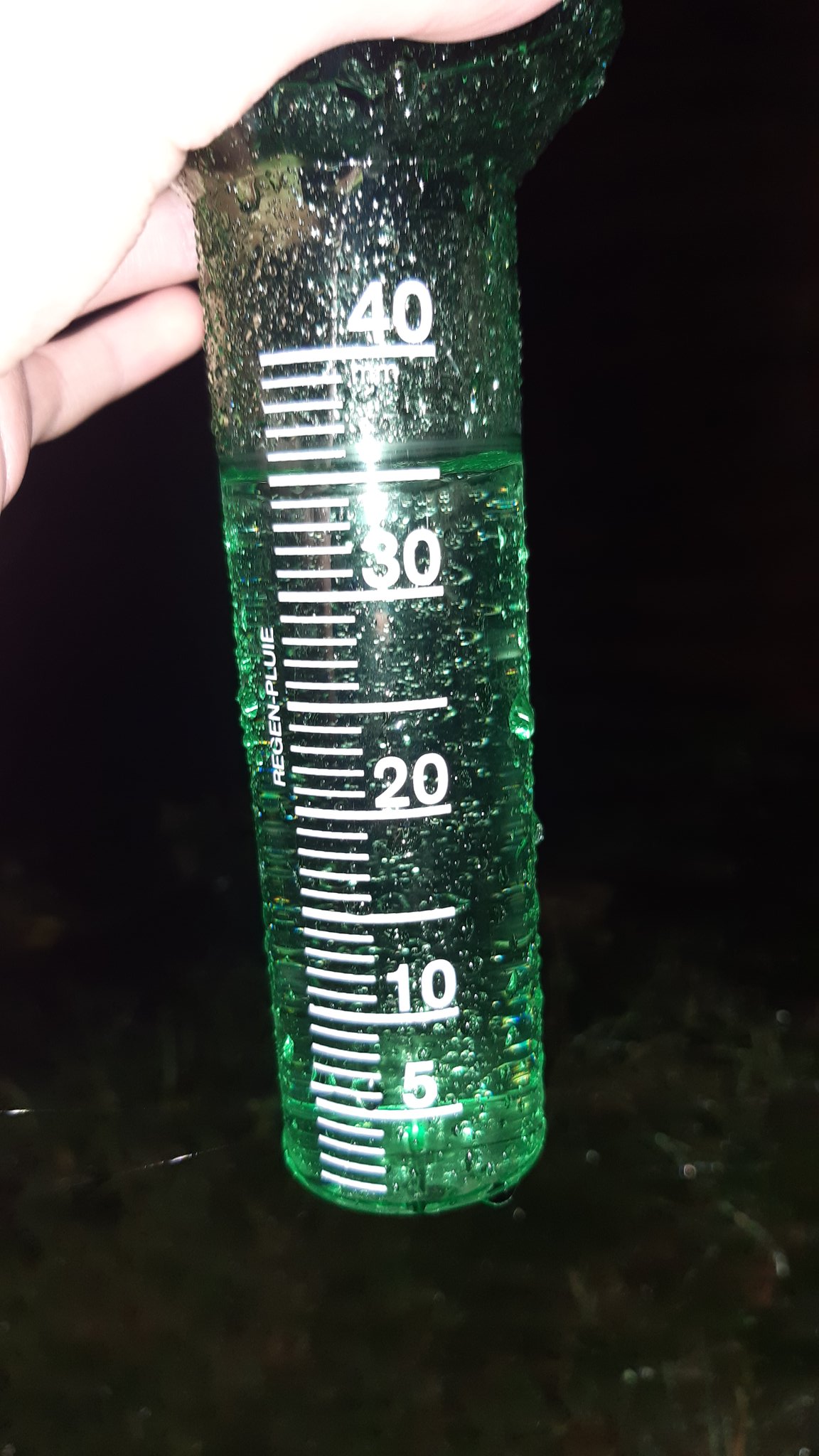
Manual rain gauge measurement at midnight on Saturday the 3rd of October showing the amount of rain fallen in a 24 hour period.
The South is an incredibly dry climate year-round so rainfall totals like this from one or two low-pressure systems within days are unprecedented & don’t happen often like this. You’d normally expect to see such high rain totals at the start of the month in the North, not in the center of the South.
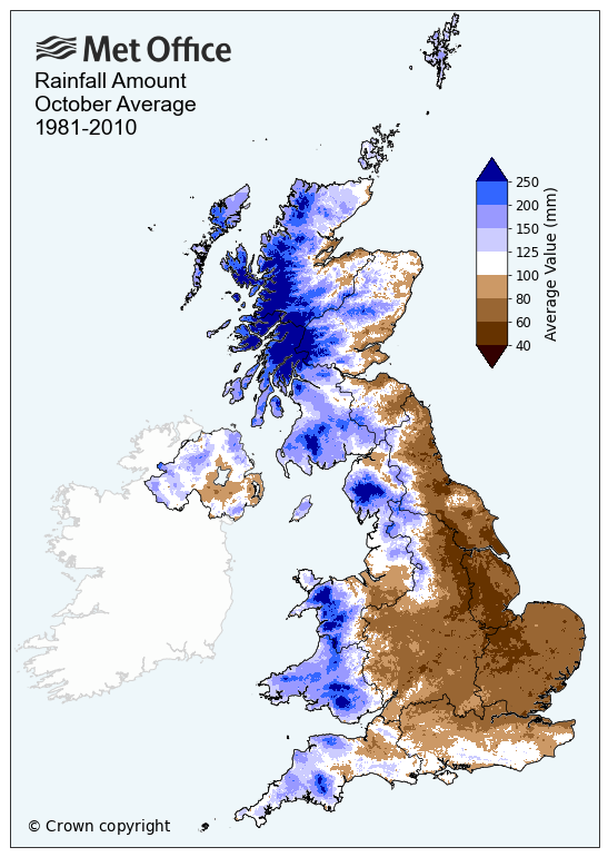
October’s average rainfall from the Met Office.
The start of October’s synoptic setup has been much like last year with a southerly jetstream & low pressure in full force, dumping over 100 mm at Manston. Last year was just not so wet.
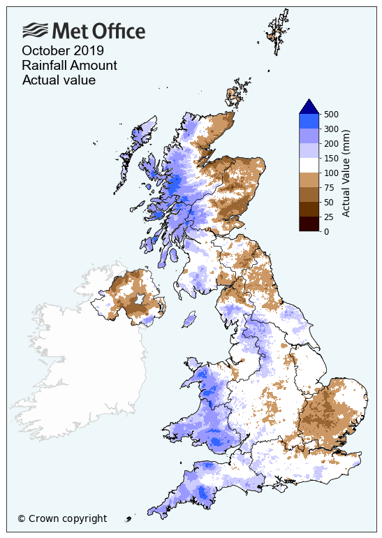
October 2019 monthly rainfall map from the Met Office, showing much of the South within 100 mm.
The main cause of this was the continuous rainfall from Storm Alex after which a low-pressure system formed in France, bringing weather fronts to the UK which very much halted over the UK for a long period of time, adding onto the already wet period & totals just rising & rising, well into 50/60mm.
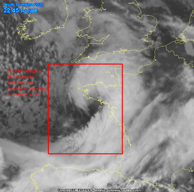
Storm Alex hanging out in the channel & just into France on Friday started off the rainfall & it just kept on going & going & going. You can see below see an occluded front sat over the South precluding the arrival of other occluded fronts & troughs, bringing continuous endless rain from nearby France into the UK, as Storm Alex moved slightly north into the Channel.
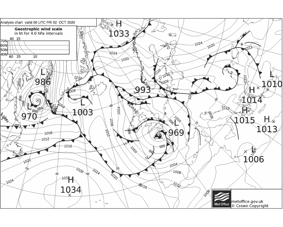
Synoptic analysis from the Met Office at 00:00 UTC on Friday the 2nd of October.

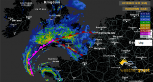
Rainfall radar at 00:00 UTC, showing the rainfall from France slowly moving North into the UK, bringing a good amount of rain.
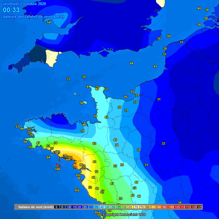
Rainfall totals were already well into their 30/40 mm range in many places on Friday evening with no end in sight for the rain to be seen as it just kept on coming & coming from nearby France.
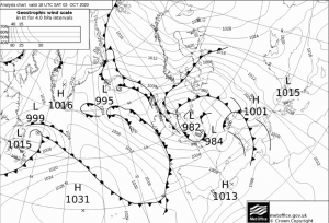
The 18:00 UTC synoptic analysis from the Met Office does show this pretty well with three different weather fronts interlinked over Central Southern England, bringing copious, non-stopping rainfall.
The 18:00 UTC synoptic analysis map from the Met Office.
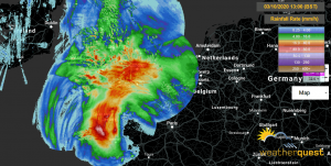
Rainfall radar at 18:00 UTC on Friday the 2nd of October with weather fronts.
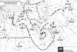
As Storm Alex pulled away south during the night, a new low-pressure system formed in Northern France & further helped these interlinked cold & warm fronts stall over Central Southern England. These, in turn, allowed the rain totals to further build & build with many places into the 50/60 mm range from the two days.

The 06:00 UTC synoptic analysis map from the Met Office on the 3rd of October.

Rainfall radar at 06:00 UTC on the 3rd of October with weather fronts drawn on.
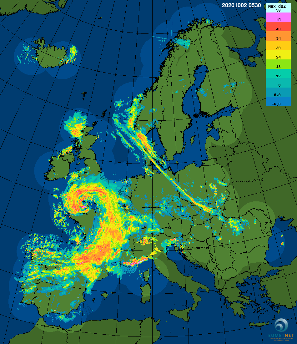
Radar estimates at 12:00 UTC on Saturday show the true extent of how wet it had been with many areas into 50 mm of rain combined from both days totals. Many areas had been stuck under the rain for many, many hours.
Radar estimated 24-hour rainfall totals at 12:00 UTC on Saturday the 3rd of October.
The rain then moved west & stalled for a brief period in the SW & into Wales in the afternoon, bringing rainfall of well over 30 mm widely. As the evening started, this rain started to move ESE incredibly slowly, intensifying as it went.
The synoptic analysis map from the Met Office at 18:00 UTC on Saturday the 3rd of October.
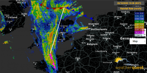
Rainfall radar at 18:00 UTC on Saturday the 3rd of October with weather fronts drawn on.

Rainfall radar at 19:45 UTC on Saturday the 3rd of October.
This culmination of events eventually leads to some places receiving well over two inches of rain in one day & nearly an inch of rain overnight on top of that. This brings many places up to well over 70/80 mm recorded within the first days of October & places many stations well into their monthly averages.
Thankfully, this rainfall does not look to return for a little while with signs of returning sunshine next weekend & into next week but still under the 13°C maximums with below average temperatures. At least the sun’s returning!
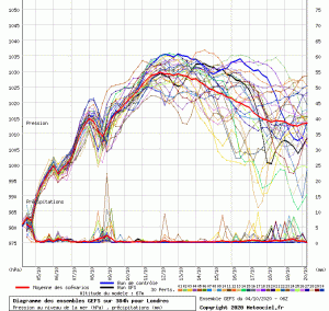
GFS pressure ensemble showing a rise in pressure over the next week.

ECMWF chart for Tuesday the 13th of October.
Enjoy the rest of your Sunday!
Jamie